
Planning your trip
Basaseachi Falls, Mexico: How to Get There, the Viewpoints and When to Go
Mexico's tallest year-round waterfall, 246 m 805 ft: drive times from Chihuahua and Creel, the two viewpoints, the 2026 entry fee, hours, weather and the day tour.
Saved on this device: you can read this guide without signal.
Email me this guide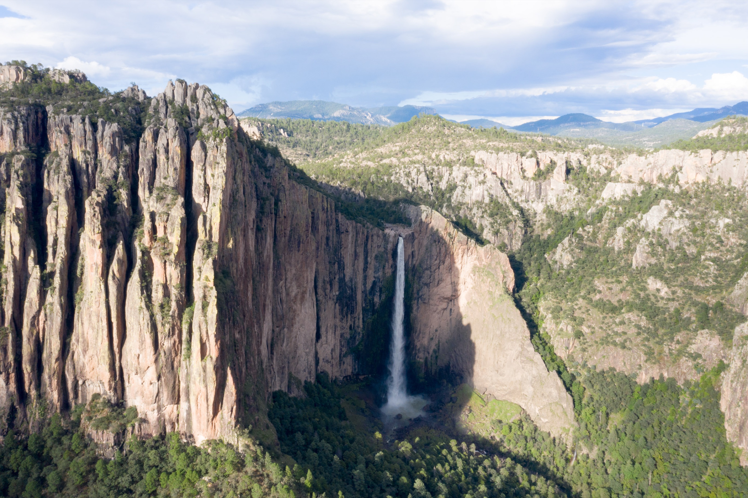
A single free fall of 246 m 807 ft into the Candameña canyon: the tallest waterfall in Mexico that runs all year, in a national park west of Chihuahua city and north of Creel.
Basaseachi (the park's legal name spells it Bassaseachic) is not on the Copper Canyon train line, so it takes a plan of its own: a long day by road from Chihuahua or Creel, a night in the village next to the park, or a guided day trip. This guide puts the drive times, the two ways into the park, the fee, the hours and the weather on one page, so you can decide which of those fits your trip.
If you would rather not drive, the Basaseachic Falls National Park Excursion on Civitatis picks you up at your hotel in Chihuahua city, with a guide in English and Spanish and the park entry included. Read what the tour includes before you book: the schedule is tight for the distance.
Key facts
| What it is | A waterfall with a single free fall of 246 m 807 ft, with water all year; the flow changes with the season |
| Where | Parque Nacional Cascada de Bassaseachic, municipality of Ocampo, in the Sierra Tarahumara of Chihuahua state |
| Nearby | Piedra Volada, 453 m 1,486 ft, Mexico's tallest waterfall, which only runs in the rainy season |
| From Chihuahua city | 280 km 174 mi by road, about 4 hours each way without stops |
| From Creel | 130 km 81 mi by road, about 2 hours 40 minutes each way without stops |
| Two ways in | Basaseachi village: park, then walk 800 m (0.8 km 0.5 mi) to the top of the falls · Rancho San Lorenzo: park, then walk 50 m 164 ft to a viewpoint facing the falls |
| Hours | 8:00 a.m. to 5:00 p.m., every day; the San Lorenzo viewpoint until 7:00 p.m. |
| Entry fee (2026) | MXN 125 per person per day for foreign visitors; children under 12 and people with disabilities do not pay |
| Most water | July to October, the rainy season |
| Altitude | From about 2,200 m 7,218 ft down to 900 m 2,953 ft inside the park |
| Not allowed | Pets, and camping or fires outside the marked sites |
| Bring | Cash in pesos, drinking water (the streams are not safe to drink), shoes with grip, layers |
What you will see
Most of the water comes from the El Durazno stream, joined by the Basaseachi and other creeks. It goes over the edge of the plateau into the Barranca de Candameña, a narrow, vertical and broken canyon up to 1,850 m 6,070 ft deep. Geologically, the canyon walls are mostly volcanic rock. Below the falls the water becomes the Candameña river, which crosses into Sonora as the Río Mayo and ends in the Gulf of California.
The park around the falls protects 5,803 hectares (about 14,340 acres) of pine and oak forest. The park lists 15 kinds of pine and 15 of oak, maples that turn color in the fall, and orchids, and in the warmer bottom of the canyon the forest gives way to low tropical woodland. Animals that live here include the puma, white-tailed deer, black bear, coati, raccoon and ringtail; among the birds are the thick-billed parrot, the military macaw and the mountain trogon. Several small plants grow on the edges of the pools at the base of the falls and nowhere else.
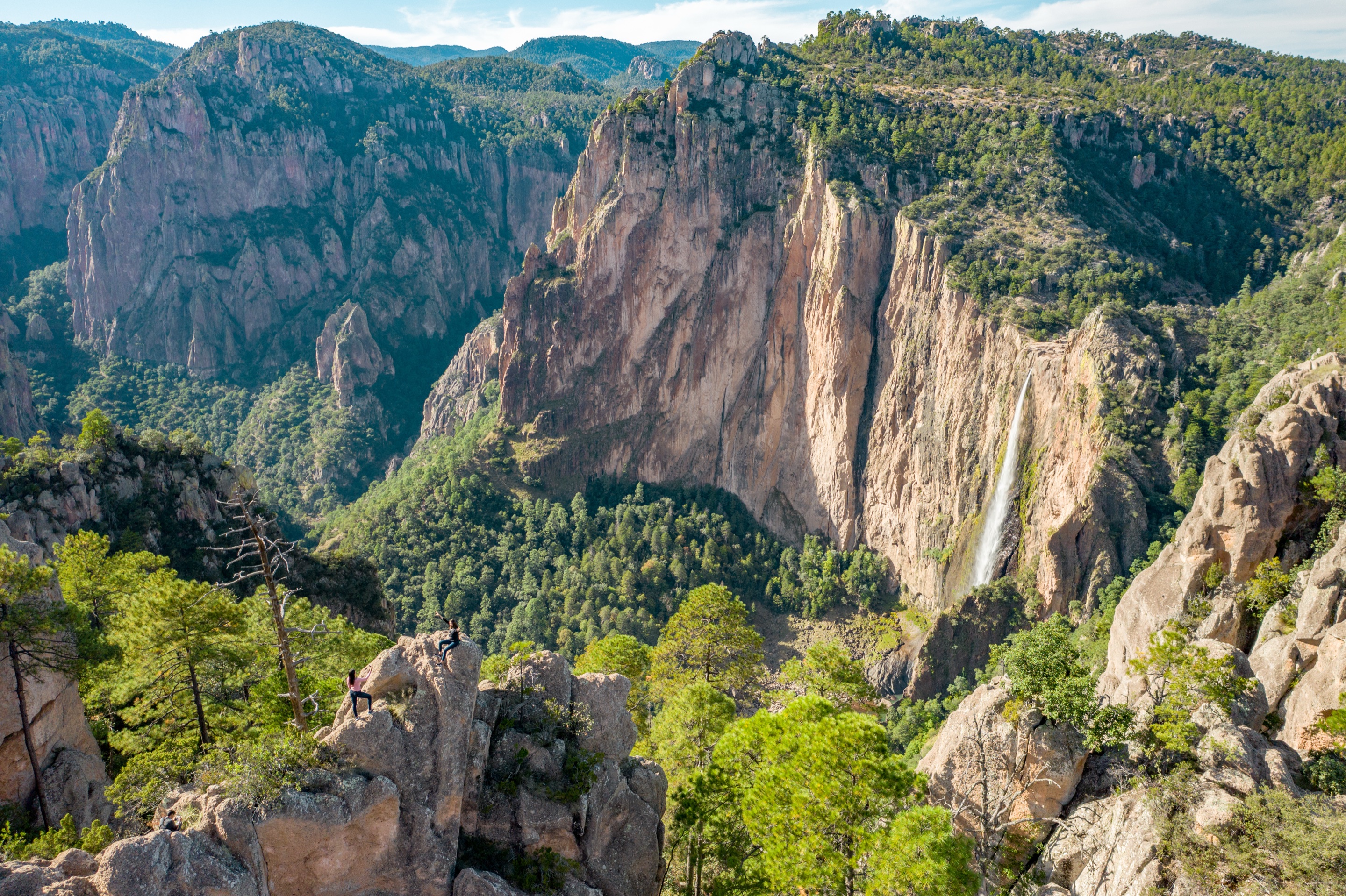
Mexico declared the area a national park on February 2, 1981. The village of Basaseachi sits just north of the falls. The Rarámuri name is translated in different ways (place of coyotes, place of the waterfall); we found no official explanation.
Some guides give the height as 247 m 810 ft or 256 m 840 ft; the official figure is 246 m 805 ft.
How to get to Basaseachi Falls
The train does not reach the park, so the last part is always by road. These are the road distances and driving times to the two parking areas, without stops and without border waits.
| From | To the San Lorenzo viewpoint | To Basaseachi village (top of the falls) | Main roads |
|---|---|---|---|
| Chihuahua city | 280 km 174 mi, about 4 h | 282 km 175 mi, about 4 h 5 min | MEX 16 west through Cuauhtémoc and La Junta |
| Cuauhtémoc | 175 km 109 mi, about 2 h 40 min | 177 km 110 mi, about 2 h 40 min | MEX 16 west |
| Creel | 130 km 81 mi, about 2 h 40 min | 136 km 85 mi, about 2 h 45 min | North to San Juanito, then state roads to Las Estrellas |
| San Juanito | 99 km 62 mi, about 2 h 5 min | 106 km 66 mi, about 2 h 15 min | State roads to Las Estrellas |
| Ciudad Juárez | 644 km 400 mi, about 8 h 50 min | 646 km 401 mi, about 8 h 55 min | MEX 45D to Chihuahua, then MEX 16 |
| El Paso, Texas (downtown) | 647 km 402 mi, about 8 h 50 min plus the border | 649 km 403 mi, about 8 h 55 min plus the border | Cross to Ciudad Juárez, then as above |
The two parking areas are 15 km 9 mi apart by road, about 20 minutes. From El Paso it is not a day trip: plan at least one night in Chihuahua city on the way.
By car from Chihuahua city
The road is Highway 16, west from Chihuahua through Cuauhtémoc, La Junta and Tomóchi to the junction of Las Estrellas. There you choose your entrance:
| Entrance | From the Las Estrellas junction | Then on foot | What you see |
|---|---|---|---|
| Basaseachi village | Follow the road into the village and keep straight on the main street to the parking area | 800 m (0.8 km 0.5 mi) | The water going over the edge |
| Rancho San Lorenzo | Take the road toward San Juanito; after 3 km 1.9 mi, turn right toward Rancho San Lorenzo and follow the paved road to its end | 50 m 164 ft | The whole fall from the front: the easiest full view if walking is hard for you |
Both access roads are paved and have parking, so a regular car is fine. The park warns about potholes on the highway. There is a gas station on the road from the Las Estrellas junction toward the village; fill up before you leave Cuauhtémoc anyway. Our guide to driving to Copper Canyon covers the permit and insurance a U.S. car needs.
Cuauhtémoc is on the way, and a stop at the Mennonite communities of Cuauhtémoc fits on the drive out or back.
By car from Creel
From Creel the road goes north to San Juanito and then northwest on state roads that end at Las Estrellas. Coming this way you reach the turnoff to Rancho San Lorenzo before you get to the junction. It is a full day: about 5 hours 20 minutes of driving there and back, plus your time in the park. Our Creel guide lists the closer sights if you want a shorter day.
Chihuahua, Basaseachi and Creel in one trip
If you are driving from Chihuahua to Creel anyway, Basaseachi can sit in the middle. It adds about 150 km 93 mi, too much for one day if you want time at the falls, so sleep in Basaseachi village and continue to Creel the next morning.
| Route | Distance | Driving time, no stops |
|---|---|---|
| Chihuahua → Creel, direct | 260 km 162 mi | About 3 h 45 min |
| Chihuahua → Basaseachi (San Lorenzo) | 280 km 174 mi | About 4 h |
| Basaseachi (San Lorenzo) → Creel | 130 km 81 mi | About 2 h 40 min |
| Chihuahua → Basaseachi → Creel, total | 410 km 255 mi | About 6 h 40 min, over two days |
Our Chihuahua to Creel guide compares the other ways of making that trip.
The day tour from Chihuahua
The Basaseachic Falls National Park Excursion on Civitatis is a guided day trip from Chihuahua city.
| Departure | 8:00 a.m., from your hotel in Chihuahua city |
| Return | Planned for 4:00 p.m., at your hotel |
| Duration listed | 8 hours |
| Guide | English and Spanish |
| Included | Hotel pickup and drop-off, transport by bus or minibus, the guide and the park entry |
| Not included | Lunch, with free time to eat at a restaurant near the park |
| Price | About US$232 (MXN 4,335) per person; see the current price on the listing |
| Cancellation | Free up to 24 hours before the start |
| Good to know | Not wheelchair accessible; not for children under 3; book at least 1 day ahead |
An honest note about the schedule: by our road numbers, Chihuahua city to the park is about 4 hours each way without stops, which already adds up to the 8 hours the listing gives for the whole day, before any time at the falls or lunch. Ask the operator, through Civitatis, how long you get in the park and what time you really get back before you book, and do not plan anything for that evening.
The viewpoints and trails
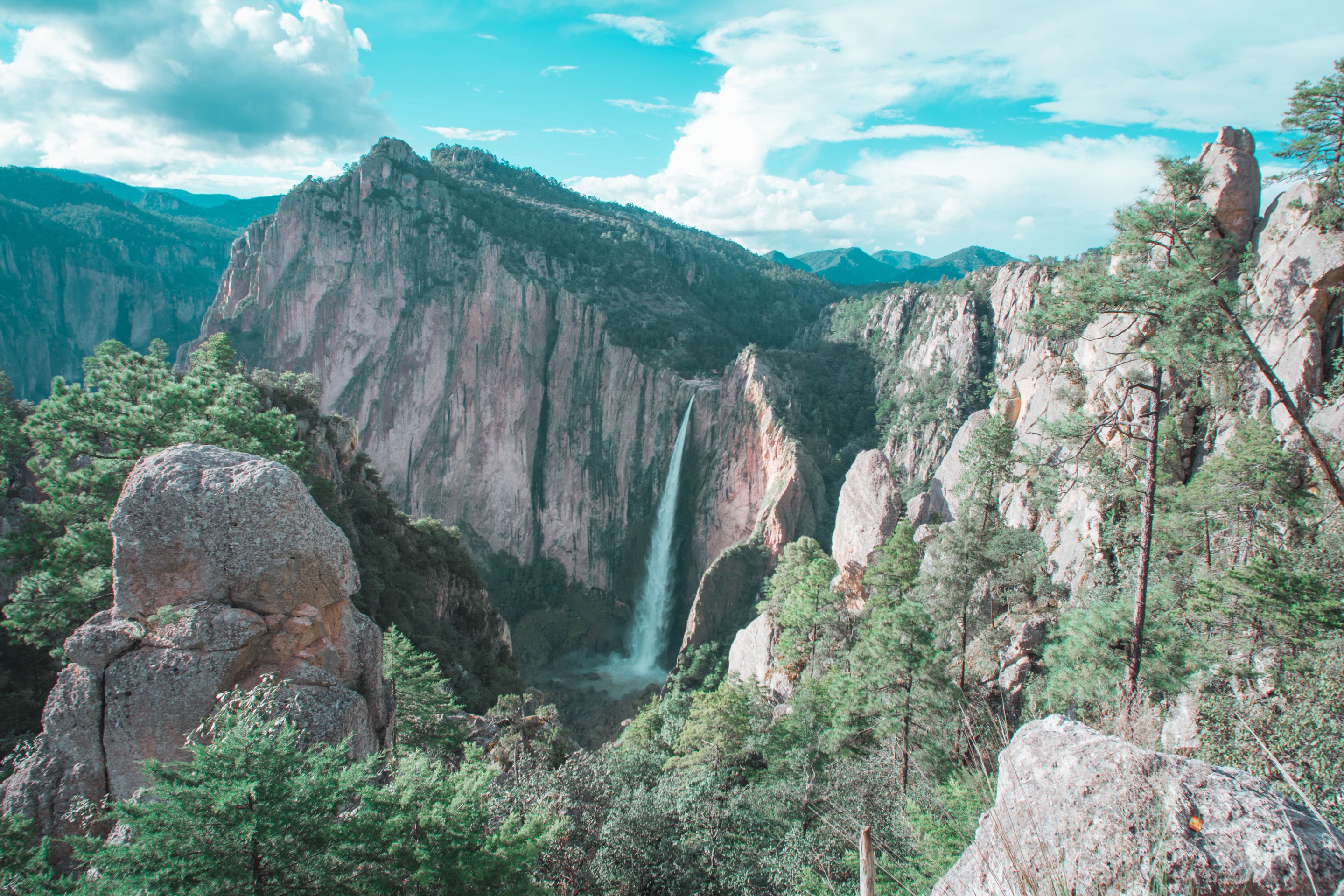
The park has stone-paved trails that are marked and signposted. The named ones are San Lorenzo, Basaseachi, La Ventana and El Plan–El Gigante, each with a viewpoint of the same name, plus three numbered viewpoints. Some viewpoints have railings and some are covered.
| Where | What you see | Walking |
|---|---|---|
| Top of the falls (from Basaseachi village) | The water going over the edge, and the canyon below | 800 m (0.8 km 0.5 mi) from the parking area |
| San Lorenzo viewpoint (from Rancho San Lorenzo) | The whole fall from the opposite side of the canyon | 50 m 164 ft from the parking area; open until 7:00 p.m. |
| La Ventana and the numbered viewpoints | The falls and the canyon from other angles | Along the rim trails of the park |
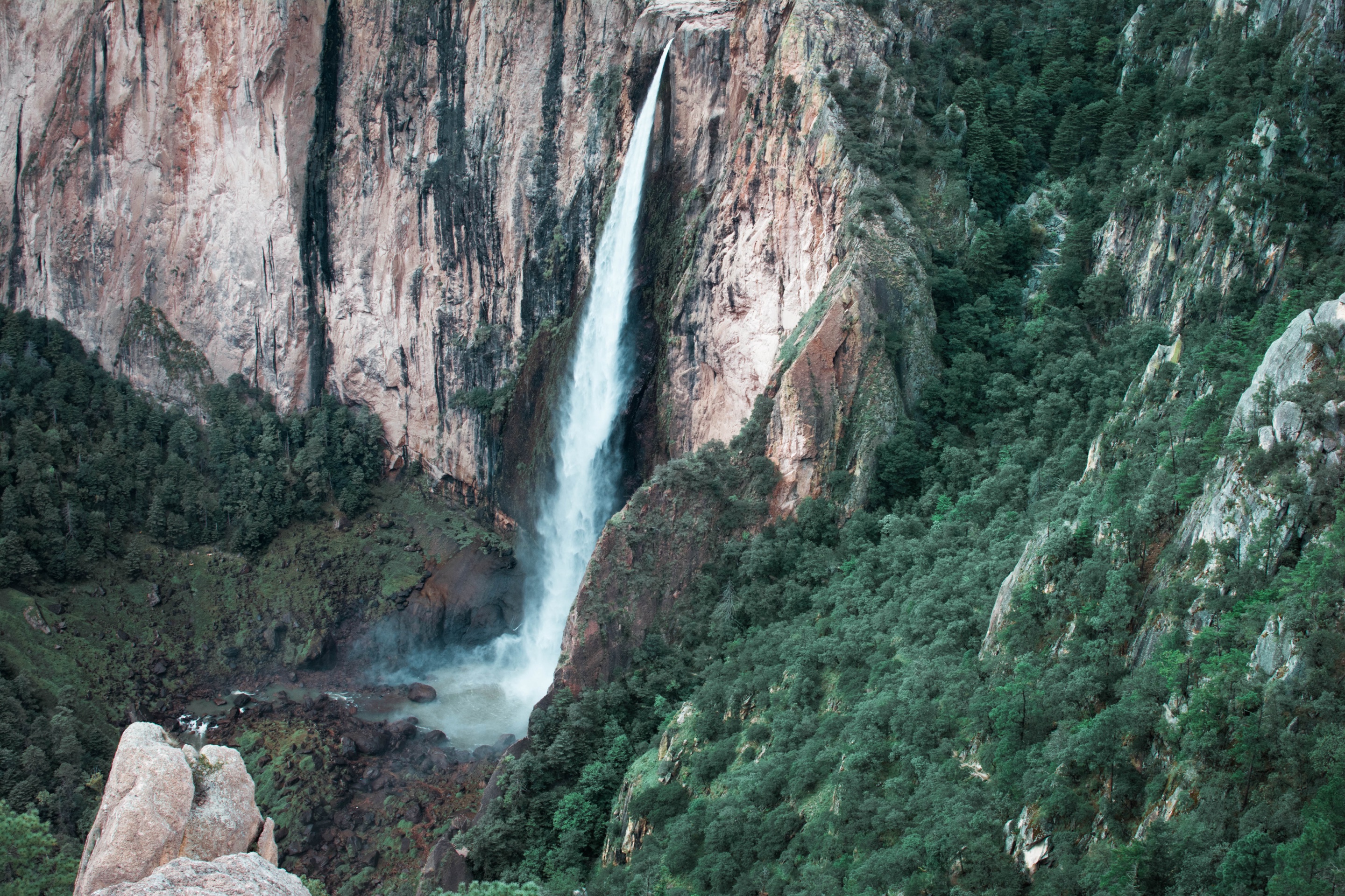
| Base of the falls | The natural pools the falls form | A steep descent into the canyon and the climb back |
| La Corona (west side) | El Gigante and Piedra Volada, head-on | A dirt road to a parking area, then a path on foot |
The hike to the bottom. Trails go down into the canyon to the pools at the base of the falls. We found no official length or time for that hike. Assume a steep descent, then the same climb back at altitude, and keep it for when you are fit, the trail is dry and you have several hours of daylight. The park's own advice: if you have high blood pressure or diabetes, or are not in good shape, do not try long explorations, and carry a walking stick and shoes that do not slip.
El Gigante is a huge rock formation on the west side of the park. The park allows rappelling in only three places, El Gigante, Rancho San Lorenzo and Cerro Bassaseachic, and rappelling and rock climbing need the corresponding permit; ask at the park before you bring gear.
Piedra Volada, the taller one
Piedra Volada is the tallest waterfall in Mexico, but it only runs in the rainy season.
| Basaseachi | Piedra Volada | |
|---|---|---|
| Height | 246 m 807 ft, single free fall | 453 m 1,486 ft |
| Water | All year; most from July to October | Only in the rainy season |
| Where | Candameña canyon | Same canyon, about 4 km 2.5 mi southwest of Basaseachi in a straight line |
| How to see it | From the top (Basaseachi village) or from the front (San Lorenzo), on paved roads | From the La Corona rock viewpoint on the west side of the park: a dirt road to a parking area, then on foot |
If Piedra Volada is the reason for your trip, go between July and October, and ask in the village or at the park whether it is running and whether the dirt road is passable before you set out.
When to go
The falls have water all year, but the flow is far bigger in the rainy season. These are the official 1991–2020 climate normals of the two closest weather stations with records for that period: rain from Yepachic, 35 km 22 mi northwest of the park at 1,790 m 5,873 ft, and temperatures from Tejolocachi, at 1,920 m 6,299 ft on the plateau 83 km 52 mi to the east, the closest one with a temperature record.
| Month | Average high | Average low | Rain | Days with rain |
|---|---|---|---|---|
| Jan | 16 °C 62 °F | -4 °C 24 °F | 39 mm (1.5 in) | 3 |
| Feb | 18 °C 64 °F | -2 °C 28 °F | 39 mm (1.5 in) | 3 |
| Mar | 21 °C 70 °F | -1 °C 30 °F | 18 mm (0.7 in) | 2 |
| Apr | 25 °C 77 °F | 2 °C 36 °F | 13 mm (0.5 in) | 1 |
| May | 30 °C 85 °F | 6 °C 43 °F | 12 mm (0.5 in) | 2 |
| Jun | 32 °C 90 °F | 11 °C 52 °F | 98 mm (3.9 in) | 10 |
| Jul | 30 °C 86 °F | 13 °C 56 °F | 284 mm (11.2 in) | 22 |
| Aug | 29 °C 84 °F | 13 °C 55 °F | 216 mm (8.5 in) | 18 |
| Sep | 28 °C 82 °F | 10 °C 50 °F | 116 mm (4.6 in) | 10 |
| Oct | 25 °C 77 °F | 4 °C 40 °F | 50 mm (1.9 in) | 4 |
| Nov | 21 °C 69 °F | -1 °C 30 °F | 30 mm (1.2 in) | 2 |
| Dec | 17 °C 62 °F | -4 °C 24 °F | 44 mm (1.7 in) | 3 |
Normals describe past averages, not the weather on your dates. The park reaches about 2,200 m 7,218 ft, higher than both stations, so expect the rim to be somewhat cooler.
What the numbers mean for a visit:
- July to September bring nearly two thirds of the year's rain and the strongest falls, with rain on most days in July. Start early, and keep off the trail to the bottom after heavy rain.
- October is the sweet spot for many travelers: the falls still carry the summer's water, the days are mild, and the forest starts to change color.
- November to March have nights below freezing. The water is lower, and January and February can bring snow to the forest.
- April and May are the driest months, usually with the least water in the falls, and warm days.
The park also publishes a calendar of what happens in the forest through the year:
| When | What happens |
|---|---|
| January–February | Snow in the forest |
| May | Cacti in flower |
| First week of July | Canyon tree frogs breed |
| July–August | Mushroom season |
| July–October | The tallest falls of Mexico at their fullest, Piedra Volada included |
| September–November | Oaks and maples change color |
For the rest of the Copper Canyon route, see our best time to visit Copper Canyon.
Fees, hours and park rules
Entry fee. Visitors to Mexican national parks pay a federal fee per person per day. These are the 2026 amounts for Basaseachi:
| Visitor | Fee per person per day |
|---|---|
| Foreign visitors | MXN 125 |
| Mexican nationals and foreign residents of Mexico, with documents | Half |
| Students and teachers with a valid card | 75 % off; whether a foreign card is accepted is up to the staff at the gate |
| Children under 12 and people with disabilities | Free |
| Pensioners and retirees | Free under the law; whether a foreign retirement card is accepted is up to the staff at the gate |
| On the Civitatis day tour | Included |
Carry cash in pesos.
Hours. The park is open from 8:00 a.m. to 5:00 p.m., seven days a week. The San Lorenzo viewpoint stays open until 7:00 p.m., which makes it the place for late light on the falls.
Rules worth knowing:
- No pets or other domestic animals in the park.
- Enter and leave through the entrance booths, and stay on the established trails.
- Drive only on the existing roads and park in the marked areas.
- Camp only in the marked camping areas, without cutting or clearing plants.
- Fires only in the marked fire sites, never left alone, and put out completely.
- Take nothing: no plants, animals, rocks or fossils.
Contact. The park office lists the phone (614) 414 76 98, extension 19501 (from the U.S., dial +52 614 414 7698), and the email crecoder@conanp.gob.mx.
Where to stay and eat
You can see the falls on a day trip, but a night nearby gives you the morning light and turns a hard day of driving into an easy one.
- Basaseachi village: small hotels, grocery stores and restaurants around the plaza. We found no Booking.com page for Basaseachi, so book directly or ask in Creel or Chihuahua.
- In the park: rustic cabins and three camping areas, with public restrooms. There are also restaurants and craft stalls in the visitor area.
- Las Estrellas: by the El Durazno river there are basic food services and a camping area.
- Creel or Chihuahua city: the easiest bases with the most hotels. See our where to stay in the Copper Canyon and things to do in Chihuahua.
Cell phone coverage in the area is limited. Download your maps and your bookings before you leave Cuauhtémoc or Creel.
Ways to visit compared
| Day tour from Chihuahua | Drive from Chihuahua | Drive from Creel | Night in Basaseachi | |
|---|---|---|---|---|
| Driving | None for you | About 8 h there and back | About 5 h 20 min there and back | About 4 h each day if you come from Chihuahua |
| Time at the falls | Ask the operator | Depends on when you leave | 2 to 4 hours, our suggestion | As much as you want, with morning and evening light |
| Piedra Volada and the bottom trail | Not in the program | Only if you start very early | Possible, tight | Yes |
| Best for | No driving, a guide in English | Travelers already in Chihuahua with a car | Travelers based in Creel | Hikers and photographers |
| Cost to plan | About US$232 per person, entry included | Fuel, any tolls and MXN 125 per person | Fuel and MXN 125 per person | A night's lodging, fuel and MXN 125 per person |
Is it safe to visit Basaseachi Falls from the U.S.?
Read the three government advisories below before you decide; they are the most current official view, and they change.
| Government | What it says about Chihuahua | What it means for Basaseachi |
|---|---|---|
| United States (advisory issued May 29, 2026) | Level 3, Reconsider travel, due to terrorism, crime and kidnapping; U.S. government employees may not travel to certain areas of Chihuahua, including Copper Canyon | The advisory includes a map of the restricted areas: check where the park and your road fall on it |
| United Kingdom | Advises against all but essential travel to the state, except Chihuahua city, the Ciudad Juárez crossing by toll road 45, toll road 45D, the Copper Canyon rail route and its towns (including Creel), the road from Creel through San Juanito to San Pedro, and highway 16 from San Pedro to Chihuahua | Basaseachi is not in those exceptions, and neither is the last stretch of road from either side: Highway 16 west of San Pedro, or the roads northwest of San Juanito |
| Canada (last updated October 19, 2026) | Avoid non-essential travel to Chihuahua, excluding Chihuahua City | The park is outside the exception |
What that means in practice, if you decide to go:
- Travel by day. The park closes at 5:00 p.m. anyway; plan to be off the highway before dark.
- Consider the guided tour or a local guide instead of driving yourself, and take the main highway rather than shortcuts.
- Tell someone your plan and when you expect to be back. Cell coverage is limited, so do not count on your phone in the sierra.
- Check your insurance. Some policies limit cover where a government advises against travel; our guide to travel insurance for Mexico explains what to look for.
Our page on safety in the Copper Canyon goes through the advisories in more detail.
Checklist to print
| ☐ | Take or do | Why |
|---|---|---|
| ☐ | Cash in pesos | The MXN 125 entry per person, food and fuel |
| ☐ | Passport; the import permit and Mexican insurance for a U.S. car | You need them on the road |
| ☐ | Drinking water for everyone and snacks, in a small backpack | The streams are not safe to drink |
| ☐ | Shoes with grip and a walking stick | Stone trails and steep sections |
| ☐ | Layers, and a rain jacket from June to October | Frost on winter mornings, rain on most days in July and August |
| ☐ | Offline maps and your bookings saved on your phone | Cell coverage is limited |
| ☐ | A full tank before you leave Cuauhtémoc or Creel | The nearest gas station we know of is by the Las Estrellas junction |
| ☐ | Someone at home who knows your route and your return time | In case of a delay without signal |
| ☐ | The tour voucher on your phone, if you booked one | The tour uses an electronic voucher |
For the rest of the trip, our Copper Canyon packing list goes season by season.
Frequently asked questions
How tall is Basaseachi Falls?
It drops 246 m 807 ft in a single free fall. It is the tallest waterfall in Mexico with water all year; Piedra Volada, nearby, is taller at 453 m 1,486 ft but only runs in the rainy season.
How far is Basaseachi Falls from Creel?
About 130 km 81 mi by road to the San Lorenzo viewpoint, roughly 2 hours 40 minutes each way without stops.
Can I take the Copper Canyon train to Basaseachi?
No. The train does not go near the park. Most visitors drive or take a tour from Chihuahua city, or drive from Creel.
How much does it cost to enter the park?
MXN 125 per person per day for foreign visitors in 2026. Children under 12 and people with disabilities do not pay.
When does Basaseachi Falls have the most water?
In the rainy season, from July to October. In April and May, the driest months, the flow is at its lowest.
Is there an easy viewpoint for people who cannot walk far?
Yes. At Rancho San Lorenzo the viewpoint facing the falls is 50 m 164 ft from the parking area. The day tour from Chihuahua is not wheelchair accessible.
Recommended hotels
Recommended tours
More of Chihuahua beyond the train: our hub of trips off the railway, with the Samalayuca dunes, Paquimé and Mata Ortiz and Namúrachi canyon.
Send me this guide
Everything on this page in your inbox: the schedules and the booking links. Handy for planning, printing or reading on the train.
Sources
- CONANP: Parque Nacional Cascada de Bassaseachic
- Diario Oficial de la Federación: summary of the management program of the Cascada de Bassaseachic National Park (2016)
- Cámara de Diputados: Ley Federal de Derechos, article 198, amounts for 2026
- Servicio Meteorológico Nacional: climate normals for Yepachic, station 8353 (1991–2020)
- Servicio Meteorológico Nacional: climate normals for Tejolocachi, station 8243 (1991–2020)
- U.S. Department of State: Mexico travel advisory
- UK Foreign, Commonwealth & Development Office: Mexico travel advice
- Government of Canada: Mexico travel advice
- OpenStreetMap: road data and routes (© OpenStreetMap contributors, ODbL)