
Planning your trip
Namúrachi Canyon, Chihuahua: The Day Trip, the Drive and the Altar in the Rock
A narrow rock gorge with an altar inside, 130 km 81 mi southwest of Chihuahua City: the guided day trip, the drive, the weather by month and what to bring.
Saved on this device: you can read this guide without signal.
Email me this guide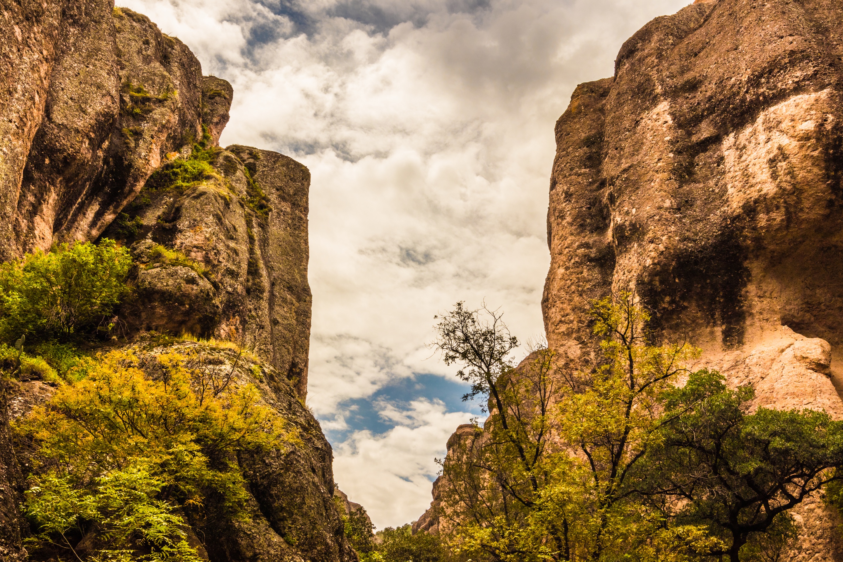
A narrow gorge of tall rock walls with an altar inside, near the old Jesuit mission town of San Francisco de Borja, about two and a quarter hours by road southwest of Chihuahua City.
If you would rather not drive, there is a guided day trip from Chihuahua City with hotel pickup, a bilingual guide and the canyon entry included: Namúrachi Canyon Day Trip on Civitatis. The details are below, with the drive for those who prefer to go on their own.
Key facts
| What it is | A deep, narrow gorge in volcanic rock with an altar inside, used at times for ceremonies and concerts |
| Where | Municipality of San Francisco de Borja, state of Chihuahua · 27.869° N, 106.711° W |
| Distance from Chihuahua City | 130 km 81 mi by road, about 2 h 15 min without stops |
| Distance from the town | 4.9 km 3 mi from San Francisco de Borja, about 12 minutes, on an unpaved road with a river ford |
| The gorge | About 750 m 2,460 ft long as mapped, with an intermittent stream along its floor |
| Altitude | San Francisco de Borja sits at 1,655 m 5,430 ft |
| Guided day trip | 7 hours from Chihuahua City, hotel pickup, guide in English and Spanish, canyon entry included · MXN 1,470 (about US$79) per person |
| Entry fee on your own | We found no official published fee; carry cash in small bills |
| Best season | October to May is dry; most rain falls from June to September |
| Time to allow | A full day from Chihuahua City |
| Accessibility | The guided trip is not wheelchair accessible; we found no official information on the trail |
Which Namúrachi is this?
Search for «Namúrachi» and you will find more than one place. The canyon in this guide is in the municipality of San Francisco de Borja, in central Chihuahua, southwest of the state capital. It is not the village of Namurachi in the municipality of Urique, in the Copper Canyon region, which lies about 130 km 80 mi farther west in a straight line, at 2,182 m 7,159 ft.
If you are entering it into a map or a GPS, use the town of San Francisco de Borja first, then the canyon parking area 4.9 km 3 mi southwest of the town. The canyon is at about 27.869° N, 106.711° W, and the parking area at its northern mouth is at about 27.875° N, 106.709° W.
What the canyon is like
Namúrachi is a deep fissure in rock that was shaped by intense volcanic activity, and what stands out is its height: a tall, vertical hollow you walk into from the parking area. Its floor follows a stream bed that carries water only at times. As mapped, the gorge is about 750 m 2,460 ft long, a short walk in distance, but one you will want to take slowly.
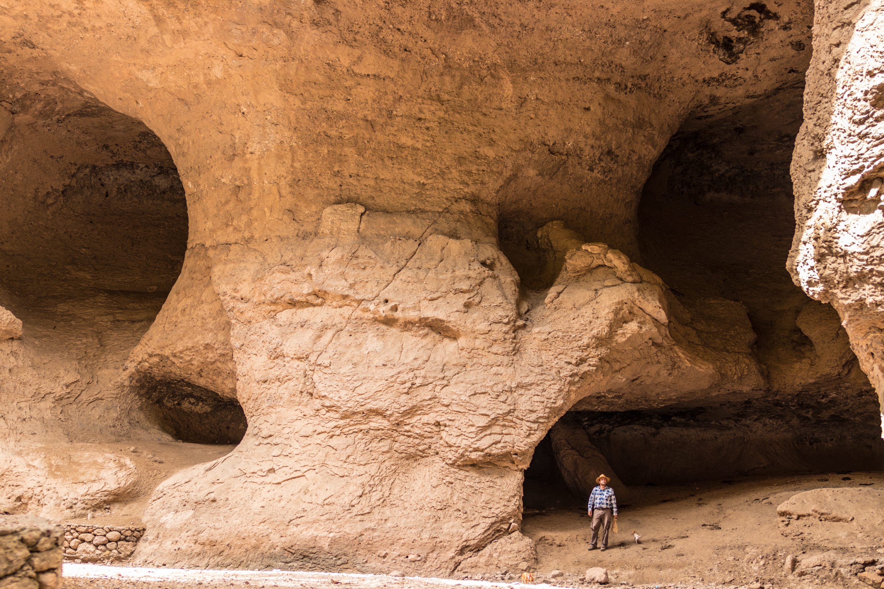
Inside the gorge there is an altar. It is used from time to time for religious ceremonies and, because of the canyon's acoustics, for concerts. In July 2019 the state's international arts festival opened its program for the Cuauhtémoc region with a percussion concert held inside the canyon.
The canyon also has its stories. A Rarámuri legend says it was once home to the Ganoko, a race of fierce giants, and links them to the rock paintings of a cave called the Cueva de la Mona. Another local story holds that generals of the Mexican Revolution buried money, gold and other valuables in this broken terrain.
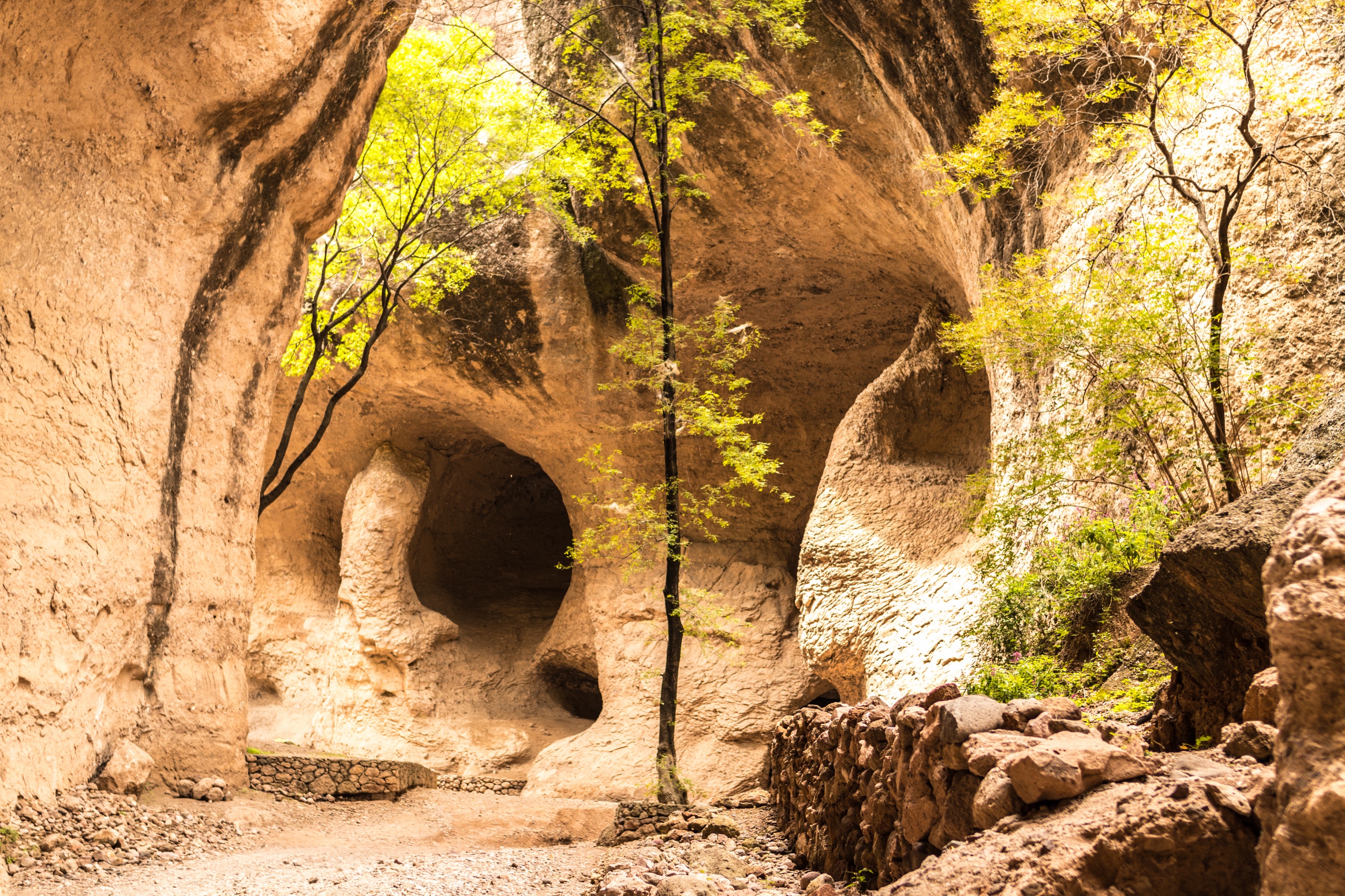
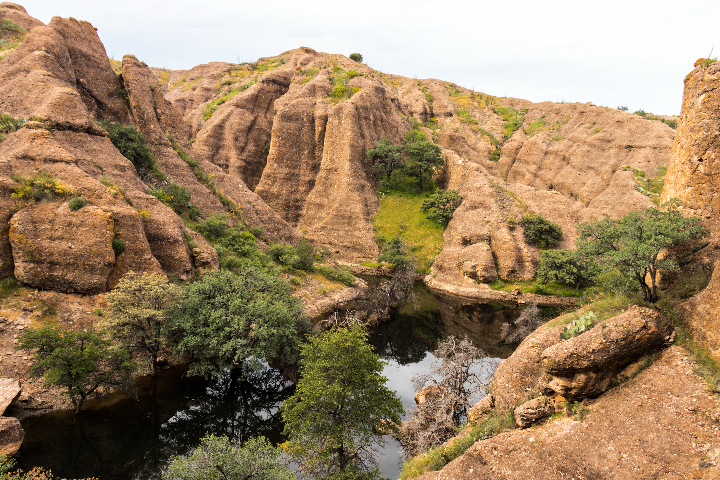
The approach is part of the visit. On the way you pass views of the Namúrachi dam, the San Pedro River and the mountains around them, with natural lookouts along the ridges. Walking is the main thing to do here, starting with the approach itself: the walk through the gorge, plus whatever time you spend around its mouth, is the visit. We found no official information on shops or services at the canyon, so bring what you need for the day.
San Francisco de Borja: the town at the gate
The canyon is reached through San Francisco de Borja, a small town founded by the Jesuits in 1645. The guided day trip stops at the town's old mission church.
The town is also the base for the 10K Namúrachi, a long-running road race. Its eighth edition, in November 2018, brought 930 runners. The 2026 edition was set for November 8, starting from the town's main plaza, with a 10 km 6.2 mi race, an 11 km 6.8 mi hike and a 3 km 1.9 mi fun run, and about 3,500 participants expected, plus 40 food stands with regional dishes in the center of town. If your dates fall in early November, check the race date: expect a full town that day, and a quieter canyon on the days around it.
The easy way: the guided day trip from Chihuahua City
For most visitors from the U.S. and Canada, the guided trip is the simplest way to see Namúrachi. Someone else drives the unpaved last stretch and the ford, and the entry is already paid.
| Name | Namúrachi Canyon Day Trip |
| Duration | 7 hours, door to door |
| Starts | Pickup at your hotel in Chihuahua City, at a time set when you book |
| Route | About 2 hours by road to San Francisco de Borja and its mission church · the walk through Namúrachi Canyon and its altar · a one-hour stop in the town of Santa Isabel to eat · back to your hotel |
| Includes | Hotel pickup and drop-off, transport by minibus, an English-speaking guide, entry to Namúrachi Canyon |
| Not included | Food and drinks (the lunch in Santa Isabel is at your own expense) |
| Language | Guide in English and Spanish |
| Price | MXN 1,470 per person, about US$79 |
| Cancellation | Free up to 48 hours before; no refund after that or for no-shows |
| Booking window | Up to 2 days in advance, if seats remain |
| Accessibility | Not wheelchair accessible |
| Voucher | Electronic, shown on your phone |
Two practical points. The trip has no fixed start time on the listing, so ask at booking what time the pickup will be; with 7 hours on the road and in the canyon, an early start leaves daylight to spare. And because the lunch stop is not included, carry pesos for it.
Driving yourself
From Chihuahua City the route leaves town southwest on MEX 16, the Chihuahua–Cuauhtémoc highway, for about 62 km 39 mi. Near the community of El Aguaje, in the municipality of Gran Morelos, you turn left onto the state road CHIH 83, which runs south about 61 km 38 mi on asphalt to San Francisco de Borja. From the town to the canyon, the last 4.9 km 3 mi are unpaved and cross a river ford, with a short bridge along the way; the road ends at a parking area at the northern mouth of the gorge.
Distances and driving times
| From | Distance | Driving time | Route |
|---|---|---|---|
| Chihuahua City | 130 km 81 mi | about 2 h 15 min | MEX 16, then CHIH 83 through San Francisco de Borja |
| Cuauhtémoc | 110 km 69 mi | about 1 h 55 min | MEX 16 east, then CHIH 83 south |
| Santa Isabel (lunch stop of the tour) | 79 km 49 mi | about 1 h 30 min | MEX 16, then CHIH 83 |
| San Francisco de Borja | 4.9 km 3 mi | about 12 min | Unpaved road with a ford |
| Creel | 264 km 164 mi | about 4 h 15 min | CHIH 25 to La Junta, MEX 16, then CHIH 83 |
| Ciudad Juárez (across from El Paso) | 494 km 307 mi | about 7 h | MEX 45 and 45D to Chihuahua, then MEX 16 and CHIH 83 |
Times are for a car with no stops; allow more for the unpaved stretch, for fuel and for lunch. From Creel and from the border, Namúrachi is not a sensible day trip: spend the night in Chihuahua City first.
Before you drive
- Go in daylight, both ways. A 7 a.m. start from Chihuahua City puts you in the canyon by mid-morning and back well before dark.
- Check the ford after rain. The last stretch crosses a river bed. In the rainy months, from June to September, ask in San Francisco de Borja whether it is passable before you go on, and do not drive into moving water.
- Drive the unpaved part slowly. We found no official report on its condition; a car with good clearance is more comfortable.
- Fill the tank in Chihuahua City or Cuauhtémoc. We found no official list of fuel stations along CHIH 83, so do not count on one.
- Mexican auto insurance is required for a U.S. car; our driving guide covers the border, the toll roads and the permits.
When to go: weather by month
We found no weather station with published normals in San Francisco de Borja. The closest we found at a similar altitude is El Sitio, in the municipality of Satevó, 53 km 33 mi southeast at 1,600 m 5,250 ft, against the town's 1,655 m 5,430 ft. These are its long-term averages (1961–1990):
| Month | Average high | Average low | Rain | Days with rain |
|---|---|---|---|---|
| Jan | 19 °C 66 °F | 1 °C 34 °F | 7 mm (0.3 in) | 1 |
| Feb | 21 °C 70 °F | 3 °C 37 °F | 8 mm (0.3 in) | 1 |
| Mar | 25 °C 77 °F | 6 °C 42 °F | 5 mm (0.2 in) | 1 |
| Apr | 28 °C 83 °F | 9 °C 48 °F | 7 mm (0.3 in) | 1 |
| May | 32 °C 90 °F | 13 °C 56 °F | 10 mm (0.4 in) | 2 |
| Jun | 35 °C 95 °F | 17 °C 63 °F | 45 mm (1.8 in) | 4 |
| Jul | 33 °C 91 °F | 17 °C 63 °F | 112 mm (4.4 in) | 10 |
| Aug | 31 °C 88 °F | 16 °C 61 °F | 122 mm (4.8 in) | 10 |
| Sep | 29 °C 84 °F | 14 °C 58 °F | 91 mm (3.6 in) | 7 |
| Oct | 27 °C 81 °F | 10 °C 49 °F | 24 mm (0.9 in) | 3 |
| Nov | 24 °C 74 °F | 4 °C 39 °F | 10 mm (0.4 in) | 1 |
| Dec | 20 °C 68 °F | 2 °C 35 °F | 9 mm (0.4 in) | 1 |
What that means for planning:
- October, November, March and April are the most comfortable months: dry, warm afternoons and cool mornings.
- May and June are the hottest, with average highs of 90–95°F (32–35°C). Start early and carry more water.
- July to September bring about four fifths of the year's rain, mostly as afternoon storms. The gorge can be at its greenest, but the stream bed and the ford are the reason to ask before you go.
- December to February have average lows just above freezing at dawn. Midday in the canyon can be pleasant; mornings are cold.
- Spring vacation brings fire patrols. Over the Easter holidays of 2025 the state's forest brigade worked in the canyon handing out fire-prevention advice to visitors. If you picnic nearby, do not light fires outside designated spots, and report any fire to 911 or to 800-737-0000.
For the rest of the region, including Creel and the train, see our best time to visit Copper Canyon.
What it costs
| Item | Cost |
|---|---|
| Guided day trip from Chihuahua City, canyon entry included | MXN 1,470 per person (about US$79) |
| Lunch in Santa Isabel on the tour | Not included; carry pesos |
| Canyon entry on your own | We found no official published fee; carry cash in small bills |
| Hotel in Chihuahua City the night before | Varies by date; see the box at the end |
Is it safe to visit Namúrachi Canyon from the U.S.?
Here is what the governments say, so you can decide with the same information we have.
- United States: the State Department's advisory for Mexico issued on May 29, 2026 places the state of Chihuahua at Level 3, Reconsider travel, due to terrorism, crime and kidnapping. It also says U.S. government employees may not travel to certain areas of Chihuahua, including Copper Canyon, and it comes with a map of restricted areas. Read it, and check where San Francisco de Borja falls on that map, before you book.
- United Kingdom: the UK government advises against all but essential travel to the state of Chihuahua, except Chihuahua City, the border crossing at Ciudad Juárez on highway 45 and the 45D toll road to Chihuahua, the Copper Canyon rail route and the towns on it including Creel, the road from Creel through San Juanito to San Pedro, and highway 16 from San Pedro to Chihuahua. San Francisco de Borja, the state road CHIH 83 and the canyon are not among those exceptions.
- Canada: the Canadian government advises avoiding non-essential travel to the state of Chihuahua, excluding Chihuahua City. The canyon is outside the city.
In practice:
- Go with the guided trip if you are unsure about driving rural roads in Mexico: you travel with a guide and do not drive the unpaved stretch yourself.
- Travel in daylight and stay on the main highways.
- Tell someone your plan and when you expect to be back, and keep your phone charged.
- Check your insurance. Some travel policies limit cover in areas under an official advisory; ask your insurer in writing. Our travel insurance guide lists the questions to ask.
We do not promise that a place is safe or unsafe beyond what these governments publish. For the wider picture of the region, see Copper Canyon safety: what to know.
What to bring
Combine it with
- Chihuahua City: the guided trip starts and ends here. See our things to do in Chihuahua and the hub Chihuahua beyond the train.
- Cuauhtémoc and the Mennonite fields: Cuauhtémoc is 110 km 69 mi from the canyon. See the Mennonites of Cuauhtémoc.
- Nonoava: 70 km 43 mi south of the canyon, about 1 h 25 min, with a group of more than 300 caves where the Rarámuri once lived, zip lines and a via ferrata. It is also outside the UK government's exceptions.
- Copper Canyon and Creel: a different trip, best done by the train. Start with our Copper Canyon train guide, Chihuahua to Creel and things to do in Creel.
- More day trips from Chihuahua City: Basaseachi Falls, Paquimé and Mata Ortiz and the Samalayuca dunes.
Frequently asked questions
Where is Namúrachi Canyon?
In the municipality of San Francisco de Borja, in central Chihuahua, 4.9 km 3 mi southwest of the town and 130 km 81 mi by road southwest of Chihuahua City. It is not the village of Namurachi in Urique, in the Copper Canyon region.
How long does it take to get to Namúrachi Canyon from Chihuahua City?
About 2 h 15 min by car without stops, on MEX 16 and the state road CHIH 83. The guided day trip takes 7 hours door to door, including the mission church in San Francisco de Borja and a lunch stop in Santa Isabel.
Is there a tour to Namúrachi Canyon?
Yes. A 7-hour day trip from Chihuahua City includes hotel pickup, a minibus, a guide in English and Spanish and the canyon entry, for MXN 1,470 (about US$79) per person. Lunch is not included.
How much is the entry to Namúrachi Canyon?
We found no official published fee. Entry is included in the guided day trip; if you go on your own, carry cash in small bills.
Can I drive to Namúrachi Canyon in a regular car?
The highways are paved all the way to San Francisco de Borja. The last 4.9 km 3 mi are unpaved and cross a river ford. Drive that stretch slowly, a car with good clearance is more comfortable, and after rain ask in town before you continue.
What is the best time to visit Namúrachi Canyon?
October, November, March and April are the most comfortable. May and June are the hottest, and July to September bring most of the rain.
Is Namúrachi Canyon safe to visit?
The U.S. advisory places the state of Chihuahua at Level 3, Reconsider travel. The UK and Canadian governments advise against non-essential travel to the area of the canyon, outside Chihuahua City. Read the current advisories, consider the guided trip, and travel in daylight.
Recommended hotels
Recommended tours
Send me this guide
Everything on this page in your inbox: the schedules and the booking links. Handy for planning, printing or reading on the train.
Sources
- Government of Chihuahua, Secretariat of Tourism («Chihuahua es para ti»): Adventure in the Namúrachi and Nonoava canyons
- Government of Chihuahua: the 10K Namúrachi run (2026)
- Government of Chihuahua: results of the eighth 10K Namúrachi (2018)
- Government of Chihuahua: concert in Namúrachi Canyon opens the FICH 2019 in the Cuauhtémoc region
- Government of Chihuahua: forest fire prevention in Namúrachi Canyon (2025)
- INEGI: catalog of localities, San Francisco de Borja
- Servicio Meteorológico Nacional: climate normals for El Sitio, Satevó, station 8057 (1961–1990)
- U.S. Department of State: Mexico travel advisory
- UK Foreign, Commonwealth & Development Office: Mexico travel advice
- Government of Canada: travel advice for Mexico
- OpenStreetMap: road and track data (© OpenStreetMap contributors, ODbL)